Contributors
Subscribe to our newsletter
While nutrients and irrigation are major factors for crop health and development, applying more fertilisers and irrigating more often in some cases, would not improve the crop performance due to soil structure constraints.
Soil variation is one of the key issues affecting productivity across farms in Australia and more specifically, water infiltration.
Infiltration is the process by which water on the ground surface enters the soil. The infiltration rate of the soil is a measure of the rate at which soil is able to absorb rainfall or irrigation. The amount and rate of water infiltration are primarily dependent on soil hydraulic properties, including soil water retention and hydraulic conductivity. When soil is not able to absorb water, reduced growth rates and major yield penalties might be accrued across the paddock.
Spatial distribution of soil moisture is the key factor determining infiltration patterns across the field. In this blog, we aim to demonstrate how to stimulate the spatial heterogeneity of infiltration in a drainage basin using remote sensing technology with ground-truthing observations.
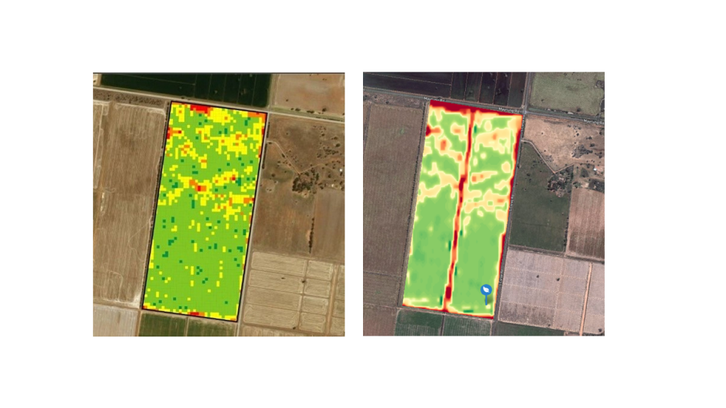
The images above show how a cornfield from Southern-New South Wales (NSW) in two consecutive seasons. The image on the left shows a previous corn season (2017) yield map where the red areas were affected by water infiltration resulted with low yields of 3,850 kg/ha dry yield as opposed to an average of 17,200 kg/ha for the entire field. On the right, a map of Red-Edge-driven index called Canopy Chlorophyll Content Index (CCCI) from the following season (January 2019) where the effects of water infiltration can be clearly seen and enabled to farmer to intervene to prevent or reduce yield loss.
Farmers and agronomists can use FluroSense remoting sensing indices such as NDVI or CCCI to guide their scouting efforts and applications after a soil anomaly is detected. The above CCCI map taken from FluroSense was used in conjunction with grid Soil Test Pro results and the previous season's yield map to identify site-specific scouting points. This enables the farmer to identify the soil constraints to be water infiltration and to intervene with the application of soil wetting agents and liquid gypsum to improve water infiltration and to minimise potential yield loss.
FluroSat's zoning tool can divide the field into actionable management zones. It can be used to quantify the severity of problem, address the farmer's focus and efforts to site-specific management zones to save resources, time and to improve yields.